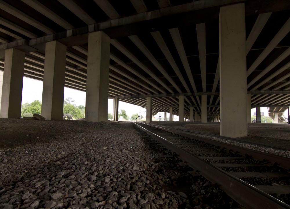
This section of concrete columns reinforcing lanes with massive steel braces replicates itself many times over to form a 1,568 mile highway that spans across eight states. Interstate 35 (I-35) was planned in the late 1940s as demand grew for greater connectivity within middle America. As the highway passes through Austin, Texas, it cements a legacy of an inequitable and discriminatory east-west divide. The road that would become I-35 was built as part of a concerted effort to create a separate (and unequal) “negro district” east of town.1 It physically and socially etched a barrier into the landscape.
Once created, spatial patterns condition how we live our lives, interact with one another, and perceive the world. The social and the spatial become mutually constitutive, continuously interacting to structure possibilities and define boundaries based on social relations of power. The eight lanes of I-35—double-decked, and more than two football fields wide—continues to create an east-west divide that casts Austin as a socially constructed border city. African Americans and Latinos are concentrated east of I-35 in predominantly low-income neighborhoods; while west of I-35, wealthier populations live in “an island of affluence”.2 Youth living on the east-side attend low-income, low-performing, racially segregated schools, and are less likely to enroll in four year colleges.3 The same path which promises greater access to opportunity, can enhance the mobility of some while “entrench[ing] the spatial imprisonment of others”.4
The highway and the railroad that bisects it, divides the landscape into a network of binary paths. You have the option to travel north-south, east-west, and toward or away from a given destination. This dialectic imaginary is an ingrained way of perceiving relationships, particularly those concerning mobility. Progress—bodily, material, social—is represented as moving away from a particular place and toward a better, more advantaged position. This dichotomy, however, is problematic. It perpetuates the belief that categories must be ranked in opposition to one another, whereby one side is privileged while its other is devalued.5 In such a context, east Austin remains fixed in place, perpetually on the ‘other side’ of boundaries that demarcate privilege and opportunity.
As I reflect on this image, I am reminded of how I captured the picture by abandoning the confines of designated lanes, and moving within peripheral spaces. I expected to forge my own path, but was surprised to find faint trails in the grassy edges of access roads, near the base of intersection signs, and along the gravel underneath the highway. These footsteps from the margins, reflect de Certeau’s argument that contradictory movements, like walking, can manipulate panoptic attempts of social organization and enunciate new ways of being in the world.5 We can transgress historic paths of exclusion; move off fixed, one-way roads, and seek more inclusive possibilities. Reframing new social and spatial mobilities, however, may require learning how to recognize our embodiment in the urban landscape, particularly in places we see without physically inhabiting.